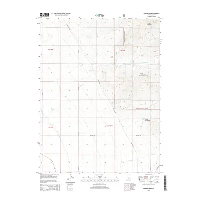
2014 Map of Duggins Creek
USGS Topo · Published 2014About this map
The eastern edge of the Pahvant Valley meets the high elevations of the Canyon Mountains and Church Mountains in this Millard County landscape. This 2014 survey captures a transition from agricultural infrastructure to wildlands, notably through the Central Utah Canal and the detailed irrigation works of the Church Spring Ditch and E Fork Ditch. Much of the eastern portion is protected within the Fishlake National Forest, where a network of ephemeral streams like Whisky Cr and Duggins Cr drain the high slopes. The map also documents the rural transportation grid, from the precisely named Whiskey Creek Rd and N Coats Rd to the historic route of Sheep Trail Rd, reflecting the region's ranching and water-management heritage.
Find a feature on this map
38 named features on this map. Tap any name to fly to it.
Don’t see what you’re looking for? This feature index may not catch every label — zoom into the map to look around manually.
Map Details
Editions of this 2014 Duggins Creek Map
This is the sole edition of this map. No revisions or reprints were ever made.
Other maps of this area

1885 · Sevier Desert
USGS Topo · 1:250,000

1951 · Oak City
USGS Topo · 1:62,500

1952 · Scipio North
USGS Topo · 1:62,500

1953 · Delta
USGS Topo · 1:250,000

1958 · Delta
USGS Topo · 1:250,000

1962 · Delta
USGS Topo · 1:250,000
1962 · The Sink
USGS Topo · 1:24,000
1962 · Holden
USGS Topo · 1:24,000

1962 · Holden
USGS Topo · 1:62,500
1969 · Scipio Pass
USGS Topo · 1:24,000