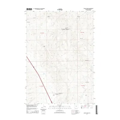
2015 Map of Dugout Ranch
USGS Topo · Published 2015About this map
Dugout Ranch serves as the namesake and primary human footprint in this corner of Johnson County, situated where Dugout Cr winds through a landscape defined by an intricate network of drainage channels. The land is carved by numerous named draws and gulches, including Dogtown Draw, Ellison Draw, and Lone Tree Gulch, which feed into larger systems like Crooked Cr. This 2015 survey illustrates how modern infrastructure, such as Interstate 87 and Interstate 25, bisects the traditional rangeland, creating a stark contrast between the high-speed transit corridor and the quiet water management of Quinn Reservoir. The naming of features like Monument Draw and Rider Draw suggests a local geography rooted in cattle ranching and early landmark identification, preserved even as the regional highway network expanded.
Find a feature on this map
26 named features on this map. Tap any name to fly to it.
Don’t see what you’re looking for? This feature index may not catch every label — zoom into the map to look around manually.
Map Details
Editions of this 2015 Dugout Ranch Map
This is the sole edition of this map. No revisions or reprints were ever made.
Other maps of this area

1955 · Arminto
USGS Topo · 1:250,000

1958 · Arminto
USGS Topo · 1:250,000

1961 · Kaycee NE
USGS Topo · 1:24,000

1961 · Figure 8 Reservoir
USGS Topo · 1:24,000

1961 · Dugout Ranch
USGS Topo · 1:24,000

1961 · Dead Woman Crossing
USGS Topo · 1:24,000

1961 · Wall Creek
USGS Topo · 1:24,000
1961 · Sussex
USGS Topo · 1:24,000

1962 · Arminto
USGS Topo · 1:250,000

1968 · Midwest
USGS Topo · 1:24,000