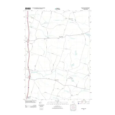
2013 Map of Dugway
USGS Topo · Published 2013About this map
Albion Center and the surrounding hamlets of Oswego County are defined by a network of local roads and the winding paths of the N Br Grindstone Cr and S Br Little Salmon River. The landscape is dotted with small settlements like Dugway, Howardville, and Maple Corners, connected by corridors such as Hong Kong Rd and Albion Cross Rd. For genealogists and local historians, the area is notable for its numerous burial grounds, including the Albion Center Cem, Old Dutch Hill Cem, and Maple Lawn Cem, which point to established rural communities. The southern edge is anchored by Parish Center and Carley Mills, while the eastern terrain includes Saint Marys Pond and Mosher Pond, illustrating a quiet, water-rich region of Upstate New York just after the turn of the 21st century.
Find a feature on this map
71 named features on this map. Tap any name to fly to it.
Don’t see what you’re looking for? This feature index may not catch every label — zoom into the map to look around manually.
Map Details
Editions of this 2013 Dugway Map
This is the sole edition of this map. No revisions or reprints were ever made.
Other maps of this area

1895 · Pulaski
USGS Topo · 1:62,500

1903 · Orwell
USGS Topo · 1:62,500

1905 · Orwell
USGS Topo · 1:62,500

1905 · Mexico
USGS Topo · 1:62,500

1906 · Kasoag
USGS Topo · 1:62,500

1943 · Pulaski
USGS Topo · 1:31,680

1943 · Richland
USGS Topo · 1:31,680
1943 · Mallory
USGS Topo · 1:31,680

1943 · Mexico
USGS Topo · 1:31,680
1943 · Central Square
USGS Topo · 1:31,680