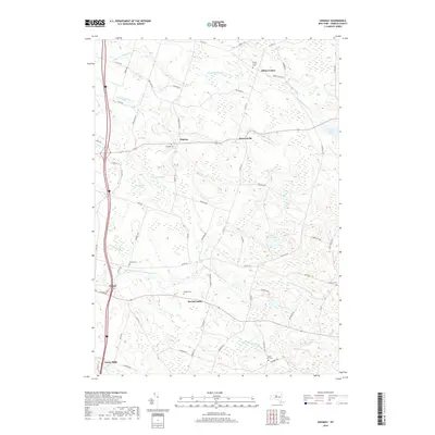
2019 Map of Dugway
USGS Topo · Published 2019About this map
Albion Center and Howardville anchor this section of Oswego County, where the landscape is defined by the complex drainage of the N Br Grindstone Cr and the North Branch Little Salmon River. The area maintains a rural settlement pattern, with small clusters of homes at Dugway and Parish Center. The prevalence of family and community burial grounds, such as Bidwell Cem, Wright Cem, and Getman Cem, suggests a long-standing local lineage tied to these specific upland farmsteads. Extensive wetlands like Steward Swamp and Kipp Swamp separate the primary roads, illustrating how the glacial geography of the region has historically dictated the placement of transit routes and small industry, such as the site of Carley Mills in the southern reaches of the quadrangle.
Find a feature on this map
64 named features on this map. Tap any name to fly to it.
Don’t see what you’re looking for? This feature index may not catch every label — zoom into the map to look around manually.
Map Details
Editions of this 2019 Dugway Map
This is the sole edition of this map. No revisions or reprints were ever made.
Other maps of this area

1895 · Pulaski
USGS Topo · 1:62,500

1903 · Orwell
USGS Topo · 1:62,500

1905 · Orwell
USGS Topo · 1:62,500

1905 · Mexico
USGS Topo · 1:62,500

1906 · Kasoag
USGS Topo · 1:62,500

1943 · Pulaski
USGS Topo · 1:31,680

1943 · Richland
USGS Topo · 1:31,680
1943 · Mallory
USGS Topo · 1:31,680

1943 · Mexico
USGS Topo · 1:31,680
1943 · Central Square
USGS Topo · 1:31,680