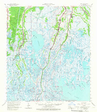
1964 Map of Dulac
USGS Topo · Published 1966About this map
Sarah Plantation and the surrounding marshlands of Terrebonne Parish dominate this mid-century topographic survey, revealing a landscape defined by the branching networks of south Louisiana bayous. The settlement patterns follow the natural levees of Bayou Terrebonne, Bayou Petit Caillou, and Bayou Grand Caillou, where the community infrastructure of churches and cemeteries is concentrated. Local heritage is deeply rooted here, visible in landmarks such as St Michaels Ch, Celestin Cem, and the Boudreaux Canal Sch.
Find a feature on this map
86 named features on this map. Tap any name to fly to it.
Don’t see what you’re looking for? This feature index may not catch every label — zoom into the map to look around manually.
Map Details
Editions of this 1964 Dulac Map
2 editions found
Other maps of this area

1892 · Gibson
USGS Topo · 1:62,500

1892 · Cut-Off
USGS Topo · 1:62,500

1892 · Houma
USGS Topo · 1:62,500

1894 · Timbalier
USGS Topo · 1:62,500

1894 · Bayou De Large
USGS Topo · 1:62,500

1894 · Lake Felicity
USGS Topo · 1:62,500

1894 · Dulac
USGS Topo · 1:62,500

1897 · Gibson
USGS Topo · 1:62,500

1932 · Houma SE
USGS Topo · 1:31,680

1932 · Houma SW
USGS Topo · 1:31,680