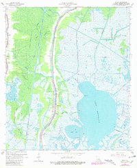
1964 Map of Dulac
USGS Topo · Published 1981About this map
Bayou Grand Caillou serves as the central artery for this coastal Louisiana landscape, where settlement patterns strictly follow the narrow natural levees between the marshes. Small community hubs like Dulac, Boudreaux, and Theriot are tightly clustered along the waterways, connected by a network that includes the massive Houma Navigation Canal and a ferry crossing. The map reveals a high density of family-named cemeteries such as Celestin Cem and Provost Cem, which are vital markers for genealogical research in this subsidence-prone region.
Find a feature on this map
38 named features on this map. Tap any name to fly to it.
Don’t see what you’re looking for? This feature index may not catch every label — zoom into the map to look around manually.
Map Details
Editions of this 1964 Dulac Map
4 editions found
Other maps of this area

1892 · Gibson
USGS Topo · 1:62,500

1892 · Houma
USGS Topo · 1:62,500

1894 · Bayou De Large
USGS Topo · 1:62,500

1894 · Dulac
USGS Topo · 1:62,500

1897 · Gibson
USGS Topo · 1:62,500

1932 · Houma SE
USGS Topo · 1:31,680

1932 · Houma SW
USGS Topo · 1:31,680

1935 · Theriot
USGS Topo · 1:31,680

1935 · Bourbeux
USGS Topo · 1:31,680

1935 · Montegut
USGS Topo · 1:31,680