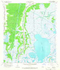
1964 Map of Dulac
USGS Topo · Published 1965About this map
Grand Caillou Bayou serves as the central artery for this coastal Louisiana landscape, where narrow strips of inhabited land are hemmed in by expansive wetlands. The settlements of Dulac and Boudreaux follow the high ground along the bayou, characterized by a dense concentration of family cemeteries and parish churches, including Holy Family Cem, Celestin Cem, and Morning Star Ch. This settlement pattern reflects the traditional relationship between the Acadian populace and the water, even as mid-century industrial changes began to reshape the environment.
Find a feature on this map
38 named features on this map. Tap any name to fly to it.
Don’t see what you’re looking for? This feature index may not catch every label — zoom into the map to look around manually.
Map Details
Editions of this 1964 Dulac Map
4 editions found
Other maps of this area

1892 · Gibson
USGS Topo · 1:62,500

1892 · Houma
USGS Topo · 1:62,500

1894 · Bayou De Large
USGS Topo · 1:62,500

1894 · Dulac
USGS Topo · 1:62,500

1897 · Gibson
USGS Topo · 1:62,500

1932 · Houma SE
USGS Topo · 1:31,680

1932 · Houma SW
USGS Topo · 1:31,680

1935 · Theriot
USGS Topo · 1:31,680

1935 · Bourbeux
USGS Topo · 1:31,680

1935 · Montegut
USGS Topo · 1:31,680