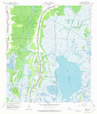
1964 Map of Dulac
USGS Topo · Published 1975About this map
Grand Caillou Bayou serves as the central artery for this marshland landscape, winding south through the settlements of Boudreaux and Dulac. In the early 1960s, the region was defined by its water-dependent infrastructure, featuring the prominent Houma Navigation Canal and several smaller waterways like Bayou Provost and Bayou Butler. The map reveals a community deeply tied to its geography, with several family and community landmarks such as Celestin Cem, Provost Cem, and the Morning Star Ch lining the high ground near the bayous.
Find a feature on this map
39 named features on this map. Tap any name to fly to it.
Don’t see what you’re looking for? This feature index may not catch every label — zoom into the map to look around manually.
Map Details
Editions of this 1964 Dulac Map
4 editions found
Other maps of this area

1892 · Gibson
USGS Topo · 1:62,500

1892 · Houma
USGS Topo · 1:62,500

1894 · Bayou De Large
USGS Topo · 1:62,500

1894 · Dulac
USGS Topo · 1:62,500

1897 · Gibson
USGS Topo · 1:62,500

1932 · Houma SE
USGS Topo · 1:31,680

1932 · Houma SW
USGS Topo · 1:31,680

1935 · Theriot
USGS Topo · 1:31,680

1935 · Bourbeux
USGS Topo · 1:31,680

1935 · Montegut
USGS Topo · 1:31,680