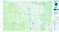
1986 Map of Dumas
USGS Topo · Published 1986About this map
The Mississippi River and Arkansas River dominate this 1980s landscape, winding through a complex network of bars, islands, and cut-offs. This period shows the agricultural and transit hubs of Southeast Arkansas established along the Missouri Pacific Railroad, including Dumas, McGehee, and Dermott. The intricate drainage patterns of Bartholomew Bayou and Bayou Macon reflect the alluvial character of the Delta, while expansive conservation lands like the White River National Wildlife Refuge and Trusten Holder State Wildlife Management Area preserve the riverine environment. Regional centers such as Monticello provide a clear view of the transition from the river bottomlands to the slightly higher timber and farm lands to the west. Localized landmarks like Seven Devils Lake and Arkansas City highlight the historical reliance on these fluctuating watercourses for both industry and settlement.
Find a feature on this map
186 named features on this map. Tap any name to fly to it.
Don’t see what you’re looking for? This feature index may not catch every label — zoom into the map to look around manually.
Map Details
Editions of this 1986 Dumas Map
2 editions found
Other maps of this area

1930 · Mellwood
USGS Topo · 1:62,500

1933 · Lamont
USGS Topo · 1:62,500

1934 · Ingalls
USGS Topo · 1:48,000

1935 · Mist
USGS Topo · 1:62,500

1935 · Feenyville
USGS Topo · 1:62,500

1935 · Cominto
USGS Topo · 1:62,500

1935 · Varner
USGS Topo · 1:62,500

1935 · Noble Lake
USGS Topo · 1:62,500

1935 · Rotan
USGS Topo · 1:62,500

1935 · Red Fork
USGS Topo · 1:62,500