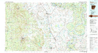
1986 Map of Dumas
USGS Topo · Published 1989About this map
Bayou Bartholomew meanders through the heart of the Arkansas Delta in this mid-1980s topographic portrait, flanked by the Mississippi River and the Arkansas River. The landscape is defined by the complex hydrology of the region, featuring numerous oxbow lakes and wetlands such as Seven Devils Lake, Cypress Brake, and Lake Cheatham. This era shows the established agricultural and transportation infrastructure of Desha, Lincoln, and Drew counties, where the Missouri Pacific RR corridor connects important rail towns like Dumas, McGehee, and Monticello.
Find a feature on this map
198 named features on this map. Tap any name to fly to it.
Don’t see what you’re looking for? This feature index may not catch every label — zoom into the map to look around manually.
Map Details
Editions of this 1986 Dumas Map
2 editions found
Other maps of this area

1930 · Mellwood
USGS Topo · 1:62,500

1933 · Lamont
USGS Topo · 1:62,500

1934 · Ingalls
USGS Topo · 1:48,000

1935 · Mist
USGS Topo · 1:62,500

1935 · Feenyville
USGS Topo · 1:62,500

1935 · Cominto
USGS Topo · 1:62,500

1935 · Varner
USGS Topo · 1:62,500

1935 · Noble Lake
USGS Topo · 1:62,500

1935 · Rotan
USGS Topo · 1:62,500

1935 · Red Fork
USGS Topo · 1:62,500