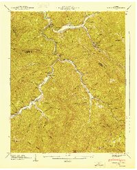
1947 Map of Duncan Flats
USGS Topo · Published 1947About this map
The winding New River carves a deep valley through the high ridges of the Cumberland Mountains, dividing Campbell, Anderson, and Scott Counties. In the late 1940s, this landscape was defined by remote mountain settlements and industrial camps, such as Clinchmore and Gennett Camp, connected by steep grades and an incline. The map documents a scattered social fabric of mountain schools like Redoak Gap Sch and Mountain Home Sch, alongside numerous family burial grounds including Ben Phillips Cem and the Ward Cem. Near the confluence of Beech Fork Tennessee River and the main river, the terrain rises sharply toward Smoky Mountain and Buffalo Mountain. These peaks and gaps, such as Lowe Gap and Brier Gap, dictate the winding paths of local life between the isolated hollows of Duncan Flats and Liza Flats.
Find a feature on this map
92 named features on this map. Tap any name to fly to it.
Don’t see what you’re looking for? This feature index may not catch every label — zoom into the map to look around manually.
Map Details
Editions of this 1947 Duncan Flats Map
This is the sole edition of this map. No revisions or reprints were ever made.
Other maps of this area

1893 · Briceville
USGS Topo · 1:125,000

1895 · Briceville
USGS Topo · 1:125,000

1896 · Briceville
USGS Topo · 1:125,000

1936 · Hogbell Gap
USGS Topo · 1:24,000

1936 · Block
USGS Topo · 1:24,000

1936 · Jacksboro
USGS Topo · 1:24,000

1936 · Duncan Flats
USGS Topo · 1:24,000

1936 · Windrock
USGS Topo · 1:24,000

1936 · La Follette
USGS Topo · 1:48,000

1936 · Norris Dam
USGS Topo · 1:48,000