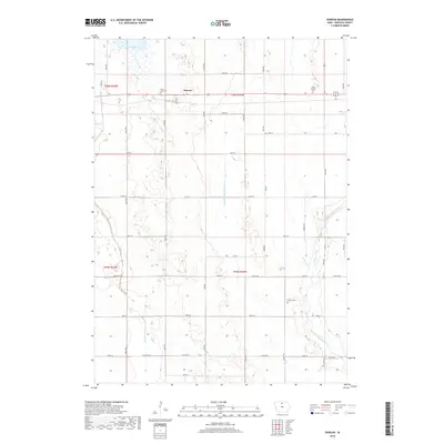
2018 Map of Duncan
USGS Topo · Published 2018About this map
Duncan serves as a central hub in this agricultural landscape of Hancock County, positioned at the intersection of a strictly gridded road network. The surrounding terrain is defined by the headwaters of the Iowa River, specifically the W Br Iowa River and the East Branch Iowa River, which meander through the prairie sections. The influence of early 20th-century land management is visible in engineered waterways like Drainage Ditch Number 6, which channel water through the flat farmland. For those researching local family history, the map preserves the locations of several burial grounds, including Saint John Cem, Saint Boniface Cem, and Liberty Cem, each situated near the township lines and local transport corridors. In the northwestern corner, Eagle Lake provides a natural break in the geometric regularity of the section lines and township boundaries like t96n r24w.
Find a feature on this map
40 named features on this map. Tap any name to fly to it.
Don’t see what you’re looking for? This feature index may not catch every label — zoom into the map to look around manually.
Map Details
Editions of this 2018 Duncan Map
This is the sole edition of this map. No revisions or reprints were ever made.
Other maps of this area

1954 · Mason City
USGS Topo · 1:250,000

1954 · Waterloo
USGS Topo · 1:250,000

1955 · Waterloo
USGS Topo · 1:250,000

1957 · Mason City
USGS Topo · 1:250,000

1958 · Mason City
USGS Topo · 1:250,000

1972 · Kanawha
USGS Topo · 1:24,000

1972 · Hayfield
USGS Topo · 1:24,000

1972 · Olaf
USGS Topo · 1:24,000

1972 · Crystal Lake
USGS Topo · 1:24,000
1972 · Duncan
USGS Topo · 1:24,000