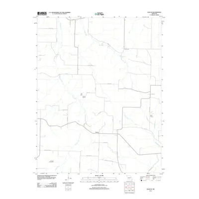
2012 Map of Duncan
USGS Topo · Published 2012About this map
Duncan serves as a central point of reference in this portion of Wright County, where the rural landscape is defined by a network of winding roads and significant watercourses. The local history of the area is preserved in the naming of sites like the Hiatt Post Office and several family or community burial grounds, including Petat Cemetery, Sixteenth Cemetery, and Mount Olive Cemetery. The terrain is drained by numerous streams, most notably Cantrell Creek, Hyde Creek, and Bowman Creek, which dictate the placement of early routes such as Old Church Rd and Old Buffalo Rd. In the southwestern corner, the Lawrence Brixey Dam represents a more contemporary modification of the drainage patterns. The naming of roads like Nation School Rd and Historic Rd provides genealogists with clues to the locations of former community centers and long-established travel corridors that helped settle this Missouri region.
Find a feature on this map
34 named features on this map. Tap any name to fly to it.
Don’t see what you’re looking for? This feature index may not catch every label — zoom into the map to look around manually.
Map Details
Editions of this 2012 Duncan Map
This is the sole edition of this map. No revisions or reprints were ever made.
Other maps of this area

1939 · Fordland
USGS Topo · 1:62,500

1942 · Fordland
USGS Topo · 1:62,500

1946 · Niangua
USGS Topo · 1:62,500

1948 · Niangua
USGS Topo · 1:62,500

1951 · Mansfield NE
USGS Topo · 1:24,000

1951 · Mansfield NW
USGS Topo · 1:24,000

1954 · Springfield
USGS Topo · 1:250,000

1956 · Duncan
USGS Topo · 1:24,000

1956 · Rader
USGS Topo · 1:24,000
1956 · Hartville
USGS Topo · 1:24,000