1952 Map of Duncannon
USGS Topo · Published 1990About this map
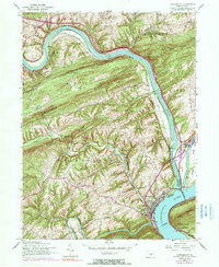
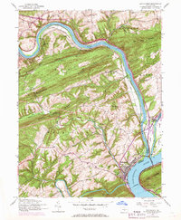
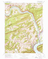
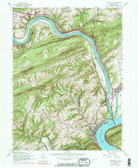
The confluence of the Juniata River and the Susquehanna River dominates this mid-century portrait of central Pennsylvania's river corridor. Situated at the base of Peters Mountain, the town of Duncannon serves as the focal point where the Penn Central railroad and the William Penn Highway intersect the water's path. The landscape is defined by the sharp, linear ridges of Dicks Ridge and Mahanoy Ridge, which channeled early development into the narrow valleys between them. Traces of 19th-century infrastructure are visible in the Abandoned Canal following the riverbank, a relic of the era when waterways were the primary arteries of commerce. Rural life is anchored by institutions like Mahanoy Union Church and the Red Hill School, while the crossing at Clarks Ferry Bridge connects the Perry and Dauphin County shores. Smaller settlements such as Benvenue and Montebello appear as quiet clusters in an area defined by its deep geological folds.
Find a feature on this map
48 named features on this map. Tap any name to fly to it.
Don’t see what you’re looking for? This feature index may not catch every label — zoom into the map to look around manually.
Map Details
Editions of this 1952 Duncannon Map
5 editions found

Other maps of this area

1892 · Harrisburg
USGS Topo · 1:62,500

1893 · Millersburg
USGS Topo · 1:62,500

1899 · Harrisburg
USGS Topo · 1:62,500

1907 · New Bloomfield
USGS Topo · 1:62,500

1907 · Millerstown
USGS Topo · 1:62,500

1924 · Harrisburg
USGS Topo · 1:62,500

1943 · Millerstown
USGS Topo · 1:62,500

1943 · Millersburg
USGS Topo · 1:62,500

1943 · Harrisburg
USGS Topo · 1:62,500

1943 · New Bloomfield
USGS Topo · 1:62,500