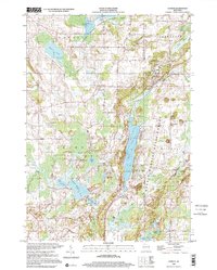
1999 Map of Dundee
USGS Topo · Published 2001About this map
The Kettle Moraine State Forest dominates this landscape on the border of Fond du Lac and Sheboygan Counties, shaped by glacial activity that left a concentrated chain of water bodies including Long Lake, Kettle Moraine Lake, and Mullet Lake. Small agricultural and residential clusters like Dundee, Armstrong, and Graham Corners are connected by a network of rural routes such as Cedar Road and Hackbarth Road. The map documents numerous local landmarks, from the Spruce Lake Bog National Natural Landmark to the Kettle Moraine Correctional Institute. Genealogists will find several burial grounds noted, including Union Cem, Mitchell Cem, and Trinity Cem, reflecting the early community structures of Osceola and Mitchell townships during the late twentieth century.
Find a feature on this map
61 named features on this map. Tap any name to fly to it.
Don’t see what you’re looking for? This feature index may not catch every label — zoom into the map to look around manually.
Map Details
Editions of this 1999 Dundee Map
This is the sole edition of this map. No revisions or reprints were ever made.
Other maps of this area

1910 · Fond du Lac
USGS Topo · 1:62,500

1954 · Kiel
USGS Topo · 1:62,500

1955 · Campbellsport
USGS Topo · 1:62,500

1955 · Kewaskum
USGS Topo · 1:62,500

1955 · Fond Du Lac
USGS Topo · 1:62,500

1957 · Madison
USGS Topo · 1:250,000

1960 · Madison
USGS Topo · 1:250,000

1974 · St. Cloud
USGS Topo · 1:24,000
1974 · Elkhart Lake
USGS Topo · 1:24,000
1974 · Dundee
USGS Topo · 1:24,000