
1953 Map of Dundee
USGS Topo · Published 1954About this map
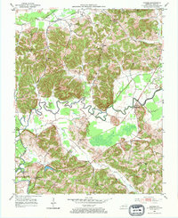
Rough River meanders in tight oxbows through the center of this 1950s landscape, defining the topography of Ohio County. The river and its tributaries, including Halls Creek and Adams Fork, carve through the terrain where numerous Oil Wells and a significant Oil Field north of Dundee indicate the area's mid-century petroleum activity. This survey captures a network of small rural communities and family landmarks, from the clusters of Ralph Cems in the north to Dukehurst in the south.
Find a feature on this map
38 named features on this map. Tap any name to fly to it.
Don’t see what you’re looking for? This feature index may not catch every label — zoom into the map to look around manually.
Map Details
Editions of this 1953 Dundee Map
2 editions found
Other maps of this area

1907 · Whitesville
USGS Topo · 1:62,500

1909 · Whitesville
USGS Topo · 1:62,500

1909 · Hartford
USGS Topo · 1:62,500

1925 · Spring Lick
USGS Topo · 1:62,500

1932 · Fordsville
USGS Topo · 1:62,500

1953 · Philpot
USGS Topo · 1:24,000

1953 · Whitesville
USGS Topo · 1:24,000

1953 · Pleasant Ridge
USGS Topo · 1:24,000
1953 · Fordsville
USGS Topo · 1:24,000

1954 · Evansville
USGS Topo · 1:250,000