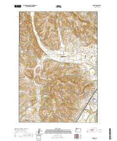
2020 Map of Dundee
USGS Topo · Published 2020About this map
Lafayette and Dundee anchor this section of the Willamette Valley, where the agricultural landscape meets the prominent elevations of the Red Hills of Dundee and Chehalem Mountains. The terrain is characterized by a series of north-south ridges, most notably Ribbon Ridge, which separates drainage basins for Stag Hollow Cr and Chehalem Cr. This survey illustrates a dense network of country roads serving numerous family-named landmarks and water sources, including Saint Josephs Reservoir, Zink Reservoir, and Kuehne Reservoir. Local heritage is anchored by three historic burial grounds: Lafayette Pioneer Cem, Dundee Pioneer Cem, and Noble Cem. The presence of multiple private landing strips, such as Ribbon Ridge Airport and Stan Jost Airport, indicates the importance of aviation in this rural corridor. Numerous named springs like Pringle Spring and Big Spring underscore the water resources that have shaped the development of Yamhill County.
Find a feature on this map
123 named features on this map. Tap any name to fly to it.
Don’t see what you’re looking for? This feature index may not catch every label — zoom into the map to look around manually.
Map Details
Editions of this 2020 Dundee Map
This is the sole edition of this map. No revisions or reprints were ever made.
Other maps of this area

1916 · Tualatin
USGS Topo · 1:62,500

1923 · Mount Angel
USGS Topo · 1:62,500

1924 · Mc Minnville
USGS Topo · 1:48,000

1926 · Mc Minnville
USGS Topo · 1:62,500

1939 · Tualatin
USGS Topo · 1:62,500

1940 · McMinnville
USGS Topo · 1:62,500

1940 · Tualatin
USGS Topo · 1:62,500

1940 · Mount Angel
USGS Topo · 1:62,500

1941 · Yamhill
USGS Topo · 1:62,500

1942 · Yamhill
USGS Topo · 1:62,500