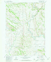
1981 Map of Dunn Basin
USGS Topo · Published 1981About this map
The Fort Hall Indian Reservation occupies the western half of this landscape, where the boundary line divides the high country of Dunn Basin from the meandering river valleys to the east. At this point in the early 1980s, the terrain is defined by the hydrologic split between the Blackfoot River and the Portneuf River, which flow through a network of remote canyons and springs. Small-scale agricultural and utility markers like storage bins and a borrow pit near Morgan Bridge signify the sparse human footprint in this corner of Idaho. Transportation is limited to rugged tracks such as the Portneuf Presto Trail and Deadman Road, reflecting a geography that remained largely focused on livestock grazing and water access. The map captures the meeting of Bingham and Caribou counties amid a complex series of drainage systems including Sunday Creek and Beaver Creek.
Find a feature on this map
17 named features on this map. Tap any name to fly to it.
Don’t see what you’re looking for? This feature index may not catch every label — zoom into the map to look around manually.
Map Details
Editions of this 1981 Dunn Basin Map
This is the sole edition of this map. No revisions or reprints were ever made.
Other maps of this area

1917 · Portneuf
USGS Topo · 1:62,500

1918 · Paradise Valley
USGS Topo · 1:62,500

1951 · Higham Peak
USGS Topo · 1:24,000

1954 · Pocatello
USGS Topo · 1:250,000

1955 · Yandell Springs
USGS Topo · 1:62,500

1955 · Idaho Falls
USGS Topo · 1:250,000

1955 · Driggs
USGS Topo · 1:250,000

1955 · Preston
USGS Topo · 1:250,000

1958 · Driggs
USGS Topo · 1:250,000

1958 · Idaho Falls
USGS Topo · 1:250,000