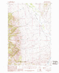
1986 Map of Dunn Creek
USGS Topo · Published 1986About this map
Deerlodge National Forest and the peaks of Bull Mountain dominate this mid-1980s landscape in Jefferson County. The map details a rugged transition between high timbered ridges and the irrigated lowlands of the Boulder Valley. Water management is central to the local geography, evidenced by the Murphy Ditch and Carey Ditch which draw from the Boulder River to support ranching in an otherwise arid climate. Genealogists and local historians will find several family-named landmarks and essential water sources, including Mc Kanna Spring, Quaintance Spring, and Mulvey Creek. The presence of a Cem near the northern boundary and established routes like Brady Gulch and Jack Gulch reflect the enduring footprint of early homesteading and resource extraction in this part of Montana.
Find a feature on this map
36 named features on this map. Tap any name to fly to it.
Don’t see what you’re looking for? This feature index may not catch every label — zoom into the map to look around manually.
Map Details
Editions of this 1986 Dunn Creek Map
This is the sole edition of this map. No revisions or reprints were ever made.
Other maps of this area

1886 · Fort Logan
USGS Topo · 1:250,000

1888 · Three Forks
USGS Topo · 1:250,000

1889 · Helena
USGS Topo · 1:250,000

1893 · Helena
USGS Topo · 1:250,000

1893 · Dillon
USGS Topo · 1:250,000

1894 · Three Forks
USGS Topo · 1:250,000

1895 · Three Forks
USGS Topo · 1:250,000

1899 · Boulder
USGS Topo · 1:125,000

1899 · Helena
USGS Topo · 1:250,000

1903 · Helena
USGS Topo · 1:250,000