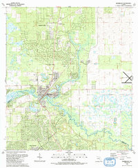
1991 Map of Dunnellon
USGS Topo · Published 1991About this map
The confluence of the Withlacoochee River and the spring-fed Rainbow River anchors this 1991 snapshot of Marion and Citrus Counties. The town of Dunnellon serves as a central hub, where established residential grids around Pennsylvania Ave and Park Ave meet the evolving suburban developments of Rainbow Lakes and Citrus Springs. This era shows a community in transition, with civic infrastructure like the Middle Sch and Dunnellon High Sch supporting growth, while the Old Railroad Grade and Dunnellon Lookout Tower speak to the area's older industrial and forestry roots. Numerous local congregations, including Beulah Ch, Holy Faith Ch, and the Church of St John the Baptist, are mapped alongside the Rockwell Cem, providing a detailed record for genealogists. The presence of the Dunnellon Airport to the east and the Golf Course to the north further illustrates the region's late-century recreational and transportation landscape.
Find a feature on this map
38 named features on this map. Tap any name to fly to it.
Don’t see what you’re looking for? This feature index may not catch every label — zoom into the map to look around manually.
Map Details
Editions of this 1991 Dunnellon Map
This is the sole edition of this map. No revisions or reprints were ever made.
Other maps of this area

1892 · Dunnellon
USGS Topo · 1:62,500

1894 · Dunnellon
USGS Topo · 1:62,500

1895 · Tsala Apopka
USGS Topo · 1:62,500

1954 · Holder
USGS Topo · 1:24,000

1954 · Crystal River
USGS Topo · 1:24,000

1954 · Romeo
USGS Topo · 1:24,000

1954 · Tsala Apopka NE
USGS Topo · 1:24,000

1954 · Dunnellon
USGS Topo · 1:24,000

1954 · Cotton Plant
USGS Topo · 1:24,000

1954 · Dunnellon SE
USGS Topo · 1:24,000