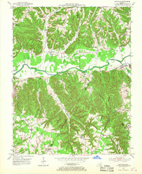
1953 Map of Dunnville
USGS Topo · Published 1969About this map
The Green River carves a broad valley through the center of this terrain, serving as the primary geographic anchor between Pellyton and Dunnville. Surveyed in the early 1950s, the landscape is defined by a dense network of ridges and hollows, where local life centered around small schools and churches positioned along elevated points and creek junctions. Numerous rural educational landmarks appear, including Tabernacle Sch No 1, Blair Ridge Sch, and Red Hill Sch, many of which were central to these upland communities. Genealogy researchers can trace family names through landmarks like the Austin Cem and Jones Cem, or follow the winding courses of Barnett Creek and Goose Creek. The mapping also highlights the complex political geography of the era, showing the converging boundaries of Adair, Casey, and Russell counties as they intersect across the ridges.
Find a feature on this map
52 named features on this map. Tap any name to fly to it.
Don’t see what you’re looking for? This feature index may not catch every label — zoom into the map to look around manually.
Map Details
Editions of this 1953 Dunnville Map
2 editions found
Other maps of this area

1952 · Clementsville
USGS Topo · 1:24,000

1952 · Liberty
USGS Topo · 1:24,000

1952 · Mannsville
USGS Topo · 1:24,000

1953 · Phil
USGS Topo · 1:24,000

1953 · Montpelier
USGS Topo · 1:24,000

1953 · Dunnville
USGS Topo · 1:24,000

1954 · Knifley
USGS Topo · 1:24,000

1954 · Russell Springs
USGS Topo · 1:24,000

1954 · Eli
USGS Topo · 1:24,000

1957 · Winchester
USGS Topo · 1:250,000