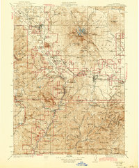
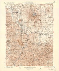
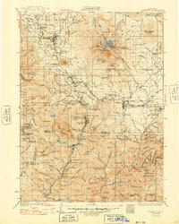
1935 Map of Dunsmuir
USGS Topo · Published 1943About this map
Dunsmuir and the surrounding river canyons dominate this mid-1930s survey of the Shasta National Forest region. The landscape is a complex intersection of industry and recreation, where the Southern Pacific RR snakes along the Sacramento River past worker-oriented settlements and quiet retreats like Shasta Retreat and Shasta Springs. To the north, the timber and rail town of Weed anchors the Shasta Valley, while the massive volcanic profile of the peak is defined by the Hotlum Glacier, Wintun Glacier, and Konwakiton Glacier.
Find a feature on this map
168 named features on this map. Tap any name to fly to it.
Don’t see what you’re looking for? This feature index may not catch every label — zoom into the map to look around manually.
Map Details
Editions of this 1935 Dunsmuir Map
4 editions found

Other maps of this area

1886 · Lassen Peak
USGS Topo · 1:250,000

1886 · Modoc Lava Bed
USGS Topo · 1:250,000

1886 · Shasta
USGS Topo · 1:250,000

1890 · Red Bluff
USGS Topo · 1:250,000

1892 · Modoc Lava-Bed
USGS Topo · 1:250,000

1892 · Lassen Peak
USGS Topo · 1:250,000

1894 · Lassen Peak
USGS Topo · 1:250,000

1894 · Red Bluff
USGS Topo · 1:250,000

1894 · Shasta
USGS Topo · 1:250,000

1901 · Redding
USGS Topo · 1:125,000