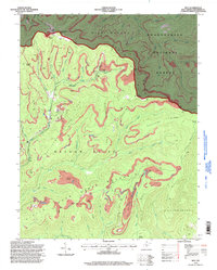
1995 Map of Duo
USGS Topo · Published 1998About this map
Industrial activity and high-elevation terrain define this portion of Greenbrier County as it was mapped in the 1990s. The small settlement of Duo serves as a central point in a landscape heavily marked by resource extraction, featuring numerous Strip Mines, a Tipple, and a Stag Dump. This extraction work is set against the backdrop of significant topographical features like Meadow Bluff Mountain and Beech Mountain, highlighting the proximity of heavy industry to the protected lands of the Monongahela National Forest.
Find a feature on this map
53 named features on this map. Tap any name to fly to it.
Don’t see what you’re looking for? This feature index may not catch every label — zoom into the map to look around manually.
Map Details
Editions of this 1995 Duo Map
This is the sole edition of this map. No revisions or reprints were ever made.
Other maps of this area

1887 · Hinton
USGS Topo · 1:125,000

1887 · Lewisburg
USGS Topo · 1:125,000

1889 · Nicholas
USGS Topo · 1:125,000

1891 · Lewisburg
USGS Topo · 1:125,000

1891 · Nicholas
USGS Topo · 1:125,000

1891 · Huntersville
USGS Topo · 1:125,000

1892 · Hinton
USGS Topo · 1:125,000

1894 · Huntersville
USGS Topo · 1:125,000

1901 · Nicholas
USGS Topo · 1:125,000

1918 · Richwood
USGS Topo · 1:62,500