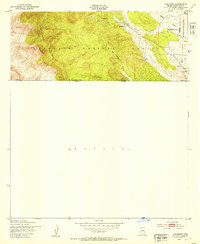
1948 Map of Duquesne
USGS Topo · Published 1953About this map
Duquesne sits within the high elevations of the Patagonia Mountains, a remote mining settlement and ranching hub near the international border. This survey, based on aerial photography from 1946 and field checked in 1948, captures the isolated character of the Coronado National Forest during the mid-century. Significant ranching landmarks are documented, including the Trask Ranch and Heady-Ashburn Ranch, along with a local Cem and several Windmill sites that sustained life in the arid high desert.
Find a feature on this map
15 named features on this map. Tap any name to fly to it.
Don’t see what you’re looking for? This feature index may not catch every label — zoom into the map to look around manually.
Map Details
Editions of this 1948 Duquesne Map
This is the sole edition of this map. No revisions or reprints were ever made.
Other maps of this area

1905 · Nogales
USGS Topo · 1:125,000

1932 · Lochiel
USGS Topo · 1:62,500

1933 · Calabasas
USGS Topo · 1:62,500

1948 · Canelo Pass
USGS Topo · 1:24,000
1948 · Lochiel SE
USGS Topo · 1:24,000

1948 · Harshaw
USGS Topo · 1:24,000
1948 · Lochiel
USGS Topo · 1:62,500

1956 · Nogales
USGS Topo · 1:250,000

1958 · Nogales
USGS Topo · 1:250,000
1958 · Lochiel
USGS Topo · 1:24,000