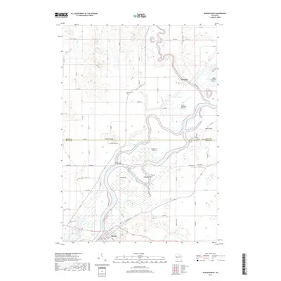
2018 Map of Durand North
USGS Topo · Published 2018About this map
The Chippewa River meanders through this portion of the Wisconsin landscape, joined by the Red Cedar River near the small settlement of Dunnville. The terrain is defined by its complex waterway network, including the Ninmile Slough and various oxbow formations such as Browning Lake and Schlosser Lake. This 2018 survey reveals a rural area dominated by natural bottomlands, specifically the Upper Dunnville Bottoms and Lower Dunnville Bottoms, which suggest a floodplain environment that has historically influenced local settlement patterns. High ground is marked by prominent local landmarks like Waubeek Mound and Yellow Bank. Genealogists and local historians can locate long-standing sites like Waubeek Cem and Evergreen Cem, while the southern portion of the sheet provides a detailed look at the street grid of Durand, showing its proximity to the riverbanks and connectivity via Co HWY V and Co HWY D.
Find a feature on this map
98 named features on this map. Tap any name to fly to it.
Don’t see what you’re looking for? This feature index may not catch every label — zoom into the map to look around manually.
Map Details
Editions of this 2018 Durand North Map
This is the sole edition of this map. No revisions or reprints were ever made.
Other maps of this area

1929 · Durand
USGS Topo · 1:62,500

1932 · Durand
USGS Topo · 1:62,500

1935 · Arkansaw
USGS Topo · 1:48,000

1940 · Menomonie
USGS Topo · 1:62,500

1941 · Arkansaw
USGS Topo · 1:62,500

1942 · Arkansaw
USGS Topo · 1:62,500

1942 · Menomonie
USGS Topo · 1:62,500

1946 · Knapp
USGS Topo · 1:62,500

1949 · Knapp
USGS Topo · 1:62,500

1953 · Saint Paul
USGS Topo · 1:250,000