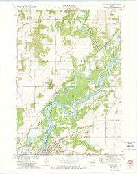
1972 Map of Durand North
USGS Topo · Published 1975About this map
The Chippewa River dominates this early 1970s landscape, winding through a complex network of backwaters and islands south of Dunnville. The confluence with the Eau Galle River and the braided channels of Ninemile Slough create a distinctive riparian environment, notably at the Lower Dunnville Bottoms. Human development is concentrated near the river’s edge, where the Chicago Milwaukee St Paul and Pacific railroad tracks trace the northern bank toward the community of Durand.
Find a feature on this map
40 named features on this map. Tap any name to fly to it.
Don’t see what you’re looking for? This feature index may not catch every label — zoom into the map to look around manually.
Map Details
Editions of this 1972 Durand North Map
This is the sole edition of this map. No revisions or reprints were ever made.
Other maps of this area

1929 · Durand
USGS Topo · 1:62,500

1932 · Durand
USGS Topo · 1:62,500

1935 · Arkansaw
USGS Topo · 1:48,000

1940 · Menomonie
USGS Topo · 1:62,500

1941 · Arkansaw
USGS Topo · 1:62,500

1942 · Arkansaw
USGS Topo · 1:62,500

1942 · Menomonie
USGS Topo · 1:62,500

1946 · Knapp
USGS Topo · 1:62,500

1949 · Knapp
USGS Topo · 1:62,500

1953 · Saint Paul
USGS Topo · 1:250,000