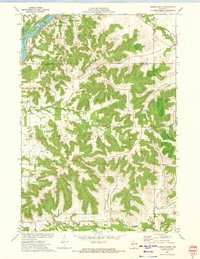
1972 Map of Durand South
USGS Topo · Published 1975About this map
The Chippewa River corridor dominates the northwest corner of this 1970s survey, where the Chicago Milwaukee St Paul and Pacific RR tracks parallel the water and the Thompson Slough. The city of Durand sits at this vital transportation junction, its corporate boundary and local features like the Sewage Disposal plant and St Mary Cem clearly delineated. Moving south and east, the landscape shifts into a complex network of ridges and valleys that define the agricultural character of Buffalo County.
Find a feature on this map
29 named features on this map. Tap any name to fly to it.
Don’t see what you’re looking for? This feature index may not catch every label — zoom into the map to look around manually.
Map Details
Editions of this 1972 Durand South Map
2 editions found
Other maps of this area

1929 · Durand
USGS Topo · 1:62,500

1932 · Wabasha
USGS Topo · 1:62,500

1932 · Durand
USGS Topo · 1:62,500

1932 · Alma
USGS Topo · 1:62,500

1935 · Arkansaw
USGS Topo · 1:48,000

1941 · Arkansaw
USGS Topo · 1:62,500

1942 · Arkansaw
USGS Topo · 1:62,500

1950 · Alma
USGS Topo · 1:62,500

1951 · Wabasha
USGS Topo · 1:62,500

1953 · Saint Paul
USGS Topo · 1:250,000