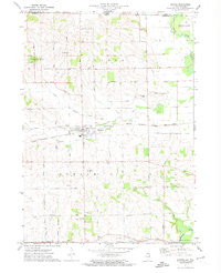
1971 Map of Durand
USGS Topo · Published 1974About this map
Durand serves as the primary hub of this northern Illinois landscape, situated at the junction of the Chicago Milwaukee St Paul and Pacific railroad and several vital rural corridors. The map records a dense network of family-named roads like Laube Rd, Crowley Road, and Patterson Road, reflecting a deeply settled agricultural community. Significant local infrastructure is present, including the McCartney Airfield and the Sewage Disposal Pond near the village center, alongside numerous community anchors such as the Durand Cem and St Marys Cem.
Find a feature on this map
62 named features on this map. Tap any name to fly to it.
Don’t see what you’re looking for? This feature index may not catch every label — zoom into the map to look around manually.
Map Details
Editions of this 1971 Durand Map
This is the sole edition of this map. No revisions or reprints were ever made.
Other maps of this area

1891 · Janesville
USGS Topo · 1:62,500

1893 · Janesville
USGS Topo · 1:62,500

1893 · Brodhead
USGS Topo · 1:62,500

1918 · Rockford
USGS Topo · 1:62,500

1932 · Pecatonica
USGS Topo · 1:62,500

1936 · Pecatonica
USGS Topo · 1:62,500

1938 · Rockford
USGS Topo · 1:62,500

1954 · Rockford
USGS Topo · 1:250,000

1955 · Rockford
USGS Topo · 1:250,000

1958 · Rockford
USGS Topo · 1:250,000