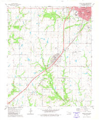
1980 Map of Durant South
USGS Topo · Published 1981About this map
The southern portion of Durant and the nearby town of Calera anchor this 1980 survey, which reveals the transition from urban density to rural landscape in Bryan County. A notable historical marker on this map is the Old Indian Treaty Boundary that cuts diagonally across the township lines, a remnant of older territorial divisions. The region's transport network is defined by two major rail lines: the St Louis - San Francisco and the Missouri - Kansas - Texas, which intersect the landscape alongside modern highways.
Find a feature on this map
35 named features on this map. Tap any name to fly to it.
Don’t see what you’re looking for? This feature index may not catch every label — zoom into the map to look around manually.
Map Details
Editions of this 1980 Durant South Map
This is the sole edition of this map. No revisions or reprints were ever made.
Other maps of this area

1899 · Atoka
USGS Topo · 1:125,000

1900 · Atoka
USGS Topo · 1:125,000

1901 · Tishomingo
USGS Topo · 1:125,000

1901 · Denison
USGS Topo · 1:125,000

1954 · Sherman
USGS Topo · 1:250,000

1957 · Denison Dam
USGS Topo · 1:24,000

1957 · Ardmore
USGS Topo · 1:250,000

1958 · Durant
USGS Topo · 1:62,500

1958 · Denison Dam
USGS Topo · 1:62,500

1958 · Sherman
USGS Topo · 1:250,000