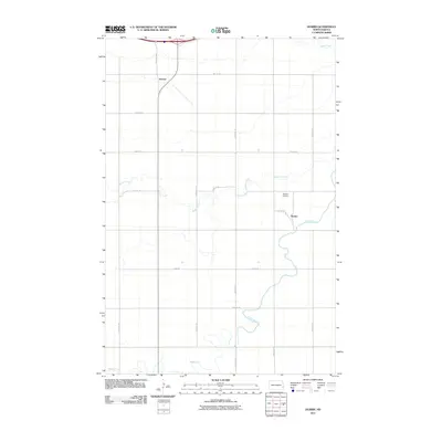
2011 Map of Durbin
USGS Topo · Published 2011About this map
Durbin sits as a central settlement in this Red River Valley landscape, characterized by the meandering path of the Maple River as it cuts through the agricultural grid. The topography is defined by the gradual convergence of prairie waterways, including Buffalo Creek and Swan Creek, which drain the surrounding farmland. The presence of the Durbin Airfield and the settlement of Everest to the northwest reflects the regional transport and aviation infrastructure. A network of section-line roads, such as 155th Ave SE and 40th St SE, organizes the terrain into the precise parcels typical of North Dakota's farming country. This survey illustrates the relationship between the natural riparian corridors and the highly structured human development of the early 21st century.
Find a feature on this map
19 named features on this map. Tap any name to fly to it.
Don’t see what you’re looking for? This feature index may not catch every label — zoom into the map to look around manually.
Map Details
Editions of this 2011 Durbin Map
This is the sole edition of this map. No revisions or reprints were ever made.
Other maps of this area

1895 · Casselton
USGS Topo · 1:125,000

1897 · Casselton
USGS Topo · 1:125,000

1953 · Fargo
USGS Topo · 1:250,000

1956 · Fargo
USGS Topo · 1:250,000

1959 · Kindred
USGS Topo · 1:24,000

1959 · Leonard
USGS Topo · 1:24,000

1961 · Durbin
USGS Topo · 1:24,000

1961 · Casselton
USGS Topo · 1:24,000
1961 · Casselton SE
USGS Topo · 1:24,000
1961 · Mapleton
USGS Topo · 1:24,000