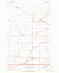
1961 Map of Mapleton
USGS Topo · Published 1963About this map
The Maple River and Rush River wind through this corner of Cass County, creating a distinct riparian pattern against the highly structured agricultural grid of the Red River Valley. At the southern edge, the town of Mapleton serves as a local hub, situated where the Northern Pacific railroad tracks and a Gaging Station meet the river's edge. Further north, the small settlements of Prosper and Newman are positioned along the Great Northern railway, illustrating the historical reliance on these rail corridors for grain transport and commerce. Local civic life is anchored by landmarks like the Townhall and the Mapleton Cem, while travelers of the era found rest at the Roadside Park along the southern highway. This survey highlights a transition in rural landscape management, with the Lower Branch Rush River feeding into the larger drainage system that defines the eastern North Dakota plains.
Find a feature on this map
20 named features on this map. Tap any name to fly to it.
Don’t see what you’re looking for? This feature index may not catch every label — zoom into the map to look around manually.
Map Details
Editions of this 1961 Mapleton Map
3 editions found
Other maps of this area

1895 · Fargo
USGS Topo · 1:125,000

1895 · Casselton
USGS Topo · 1:125,000

1897 · Fargo
USGS Topo · 1:125,000

1897 · Casselton
USGS Topo · 1:125,000

1952 · Grand Forks
USGS Topo · 1:250,000

1953 · Fargo
USGS Topo · 1:250,000

1956 · Fargo
USGS Topo · 1:250,000

1956 · Grand Forks
USGS Topo · 1:250,000

1959 · South West Fargo
USGS Topo · 1:24,000

1959 · West Fargo
USGS Topo · 1:24,000