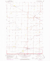
1961 Map of Mapleton
USGS Topo · Published 1977About this map
Mapleton sits at the junction of the Maple River and the Burlington Northern railroad, serving as a primary rail-and-water hub in the Red River Valley. This survey, updated with 1970s photogrammetric data, captures the transition of the prairie landscape as interstate development via Route 94 began to parallel the older path of the Burlington Northern tracks. To the north, the small settlements of Prosper and Newman follow the course of the Rush River, reflecting the linear settlement patterns driven by these critical water sources and early rail lines.
Find a feature on this map
21 named features on this map. Tap any name to fly to it.
Don’t see what you’re looking for? This feature index may not catch every label — zoom into the map to look around manually.
Map Details
Editions of this 1961 Mapleton Map
3 editions found
Other maps of this area

1895 · Fargo
USGS Topo · 1:125,000

1895 · Casselton
USGS Topo · 1:125,000

1897 · Fargo
USGS Topo · 1:125,000

1897 · Casselton
USGS Topo · 1:125,000

1952 · Grand Forks
USGS Topo · 1:250,000

1953 · Fargo
USGS Topo · 1:250,000

1956 · Fargo
USGS Topo · 1:250,000

1956 · Grand Forks
USGS Topo · 1:250,000

1959 · South West Fargo
USGS Topo · 1:24,000

1959 · West Fargo
USGS Topo · 1:24,000