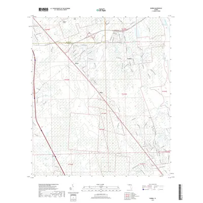
2018 Map of Durbin
USGS Topo · Published 2018About this map
Durbin and Hilden sit at the intersection of traditional Florida transport corridors and modern suburban expansion along the Duval and St. Johns county line. The Florida East Coast Railway and the historic route of Old Dixie Hwy slice diagonally through a landscape defined by massive wetland systems, including Durbin Swamp and Twelvemile Swamp. This 2018 survey reveals the residential footprints of Nocatee emerging amidst these hydrologic features, contrasting the planned developments like Valley Ridge Blvd with the preserved natural areas. To the east, the Intracoastal Waterway and Tolomato River mark the transition toward the coast, while the western portion of the map remains largely dominated by the thick vegetation of Big Island Swamp and the drainage of Durbin Creek.
Find a feature on this map
113 named features on this map. Tap any name to fly to it.
Don’t see what you’re looking for? This feature index may not catch every label — zoom into the map to look around manually.
Map Details
Editions of this 2018 Durbin Map
This is the sole edition of this map. No revisions or reprints were ever made.
Other maps of this area

1917 · Orange Park
USGS Topo · 1:62,500

1918 · Orange Park
USGS Topo · 1:62,500

1918 · Palm Valley
USGS Topo · 1:62,500

1937 · Bakersville
USGS Topo · 1:24,000

1937 · St. Augustine
USGS Topo · 1:24,000

1943 · St. Augustine
USGS Topo · 1:62,500

1947 · Bostwick
USGS Topo · 1:50,000

1948 · Jacksonville
USGS Topo · 1:250,000
1949 · Picolata
USGS Topo · 1:24,000
1949 · Bostwick
USGS Topo · 1:62,500