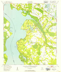
1949 Map of Picolata
USGS Topo · Published 1953About this map
The St Johns River dominates this mid-century landscape where St. Johns County meets Clay County. Along its eastern shore, small riverside communities like Picolata and Magnolia Landing maintain a foothold against the spreading wetlands and pine flatwoods. This era shows the local infrastructure of rural life, including the Picolata Sch and Mt Pleasant Ch, serving the surrounding agricultural and timber areas. Further inland, the map captures a network of creeks like Sixmile Creek and Trout Creek that drain into the main river channel. The crossing at Shands Bridge in the north and the cluster at Tocoi to the south mark significant transit points in a region defined by its water-access economy and dispersed settlements such as Elwood and Palmo.
Find a feature on this map
22 named features on this map. Tap any name to fly to it.
Don’t see what you’re looking for? This feature index may not catch every label — zoom into the map to look around manually.
Map Details
Editions of this 1949 Picolata Map
4 editions found
Other maps of this area

1917 · Orange Park
USGS Topo · 1:62,500

1918 · Orange Park
USGS Topo · 1:62,500

1918 · Palm Valley
USGS Topo · 1:62,500

1937 · Bakersville
USGS Topo · 1:24,000

1937 · Elkton
USGS Topo · 1:24,000

1943 · St. Augustine
USGS Topo · 1:62,500

1947 · Bostwick
USGS Topo · 1:50,000

1948 · Jacksonville
USGS Topo · 1:250,000

1949 · Bostwick
USGS Topo · 1:24,000

1949 · Green Cove Springs
USGS Topo · 1:24,000