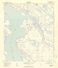
1949 Map of Picolata
USGS Topo · Published 1953About this map
The St Johns River shoreline anchors this late 1940s landscape, where small riverfront settlements and agricultural outposts dot the eastern bank. In the vicinity of Picolata, the map documents local community structures like the Picolata Sch and Mt Pleasant Ch, which served as focal points for the rural population of the era. To the north, the crossing at Shands Bridge connects St. Johns County to Clay County, while the interior is marked by drainage systems such as Trout Creek and Sixmile Creek. The presence of the Trout Creek Airport (Abandoned) and various Silos suggests a transition in local land use. Other river landings and small communities including Magnolia Landing, Palmo, and Tocoi are clearly delineated, reflecting the area's historical reliance on the waterway for transportation and commerce.
Find a feature on this map
25 named features on this map. Tap any name to fly to it.
Don’t see what you’re looking for? This feature index may not catch every label — zoom into the map to look around manually.
Map Details
Editions of this 1949 Picolata Map
4 editions found
Other maps of this area

1917 · Orange Park
USGS Topo · 1:62,500

1918 · Orange Park
USGS Topo · 1:62,500

1918 · Palm Valley
USGS Topo · 1:62,500

1937 · Bakersville
USGS Topo · 1:24,000

1937 · Elkton
USGS Topo · 1:24,000

1943 · St. Augustine
USGS Topo · 1:62,500

1947 · Bostwick
USGS Topo · 1:50,000

1948 · Jacksonville
USGS Topo · 1:250,000

1949 · Bostwick
USGS Topo · 1:24,000

1949 · Green Cove Springs
USGS Topo · 1:24,000