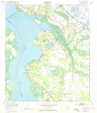
1949 Map of Picolata
USGS Topo · Published 1972About this map
St Johns River dominates this mid-century landscape of northern Florida, where the waterway serves as both a boundary for St Johns and Clay Counties and a central artery for riverfront life. The map reveals a pattern of rural communities and river landings that defined the era, from the established settlement at Picolata to the smaller riverside nodes at Magnolia Landing and Palmo. The inclusion of Picolata Sch and Mt Pleasant Ch provides critical points of interest for genealogists tracing the social foundations of these communities.
Find a feature on this map
23 named features on this map. Tap any name to fly to it.
Don’t see what you’re looking for? This feature index may not catch every label — zoom into the map to look around manually.
Map Details
Editions of this 1949 Picolata Map
4 editions found
Other maps of this area

1917 · Orange Park
USGS Topo · 1:62,500

1918 · Orange Park
USGS Topo · 1:62,500

1918 · Palm Valley
USGS Topo · 1:62,500

1937 · Bakersville
USGS Topo · 1:24,000

1937 · Elkton
USGS Topo · 1:24,000

1943 · St. Augustine
USGS Topo · 1:62,500

1947 · Bostwick
USGS Topo · 1:50,000

1948 · Jacksonville
USGS Topo · 1:250,000

1949 · Bostwick
USGS Topo · 1:24,000

1949 · Green Cove Springs
USGS Topo · 1:24,000