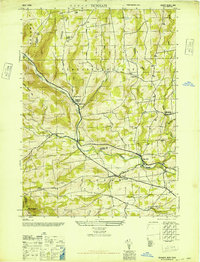
1946 Map of Durham
USGS Topo · Published 1946About this map
Catskill Creek winds through the heart of the northern Catskill foothills, defining the valley floor where the settlements of Oak Hill and Cooksburg are established. This mid-century survey by the Army Map Service and Tennessee Valley Authority documents a rural landscape transitioning from early 20th-century agriculture to a quieter residential era. The terrain is marked by significant elevations like Cheese Hill and Mt Pisgah, with local infrastructure such as School No 14 and the Sayer Sch serving dispersed farming families. Genealogy researchers can trace family plots at several locations, including Brookside Cem near Preston Hollow and Oak Hill Cem. The map's detail extends to local water sources like Tenmile Creek and Eightmile Creek, which feed into the primary drainage systems of the Rensselaerville and Durham townships.
Find a feature on this map
29 named features on this map. Tap any name to fly to it.
Don’t see what you’re looking for? This feature index may not catch every label — zoom into the map to look around manually.
Map Details
Editions of this 1946 Durham Map
2 editions found
Other maps of this area

1893 · Durham
USGS Topo · 1:62,500

1894 · Durham
USGS Topo · 1:62,500

1898 · Schoharie
USGS Topo · 1:62,500

1900 · Schoharie
USGS Topo · 1:62,500

1900 · Berne
USGS Topo · 1:62,500

1901 · Gilboa
USGS Topo · 1:62,500

1903 · Gilboa
USGS Topo · 1:62,500

1903 · Berne
USGS Topo · 1:62,500
1943 · Westerlo
USGS Topo · 1:24,000
1943 · Freehold
USGS Topo · 1:24,000