1943 Map of Freehold
USGS Topo · Published 1964About this map
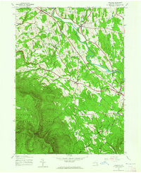
The Blackhead Mountains dominate the southwestern corner of this Greene County landscape, where the northern border of Catskill Park reaches across summits like Black Dome and Blackhead. This 1943 survey, conducted by the Army Map Service, details the transitional terrain between the high peaks and the lower valley settlements. Drainage patterns are defined by the winding course of Catskill Creek, which is fed by numerous tributaries including Basic Creek and Thorp Creek.
Find a feature on this map
36 named features on this map. Tap any name to fly to it.
Don’t see what you’re looking for? This feature index may not catch every label — zoom into the map to look around manually.
Map Details
Editions of this 1943 Freehold Map
2 editions found
Other maps of this area

1892 · Kaaterskill
USGS Topo · 1:62,500

1893 · Kaaterskill
USGS Topo · 1:62,500

1893 · Coxsackie
USGS Topo · 1:62,500

1893 · Durham
USGS Topo · 1:62,500

1894 · Coxsackie
USGS Topo · 1:62,500

1894 · Kaaterskill
USGS Topo · 1:62,500

1894 · Durham
USGS Topo · 1:62,500

1895 · Catskill
USGS Topo · 1:62,500

1899 · Kaaterskill
USGS Topo · 1:62,500

1903 · Kaaterskill
USGS Topo · 1:62,500