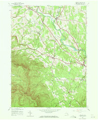
1943 Map of Freehold
USGS Topo · Published 1972About this map
Catskill Creek carves a dominant path through this 1943 landscape, serving as the central drainage for the valleys between the Blackhead Mountains and the surrounding townships. The area exhibits a classic mid-century rural settlement pattern, with small clusters of development at Freehold, East Durham, and Cairo. These villages are connected by a network of winding roads that follow the natural contours of the land, passing landmarks like St Marys Ch and Taylor Cem.
Find a feature on this map
35 named features on this map. Tap any name to fly to it.
Don’t see what you’re looking for? This feature index may not catch every label — zoom into the map to look around manually.
Map Details
Editions of this 1943 Freehold Map
2 editions found
Other maps of this area

1892 · Kaaterskill
USGS Topo · 1:62,500

1893 · Kaaterskill
USGS Topo · 1:62,500

1893 · Coxsackie
USGS Topo · 1:62,500

1893 · Durham
USGS Topo · 1:62,500

1894 · Coxsackie
USGS Topo · 1:62,500

1894 · Kaaterskill
USGS Topo · 1:62,500

1894 · Durham
USGS Topo · 1:62,500

1895 · Catskill
USGS Topo · 1:62,500

1899 · Kaaterskill
USGS Topo · 1:62,500

1903 · Kaaterskill
USGS Topo · 1:62,500