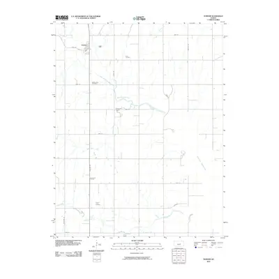
2010 Map of Durham
USGS Topo · Published 2010About this map
Durham serves as the primary hub of this Marion County agricultural landscape, situated along a section of the North Cottonwood River just before it enters the Marion Reservoir to the southeast. The area is defined by a dense grid of rural roads, including Santa Fe Ave and Kanza Rd, which connect several legacy burial grounds such as Frick Cemetery, Durham Park Cemetery, and Johannestal Cemetery. A small industrial footprint is evident at the Durham Oil and Gas Field, indicating local extraction activity. The landscape is deeply tied to its water systems, with the winding paths of Silver Creek and French Creek flowing through the territory. This 2010 survey provides a clear view of the modern rural infrastructure and the persistent landmarks of the local community, including the French Creek Cemetery situated in the southern portion of the quadrangle.
Find a feature on this map
26 named features on this map. Tap any name to fly to it.
Don’t see what you’re looking for? This feature index may not catch every label — zoom into the map to look around manually.
Map Details
Editions of this 2010 Durham Map
This is the sole edition of this map. No revisions or reprints were ever made.
Other maps of this area

1889 · Newton
USGS Topo · 1:125,000

1889 · Abilene
USGS Topo · 1:125,000

1894 · Newton
USGS Topo · 1:125,000

1894 · Abilene
USGS Topo · 1:125,000

1955 · Hutchinson
USGS Topo · 1:250,000

1959 · Hutchinson
USGS Topo · 1:250,000

1964 · Ramona
USGS Topo · 1:24,000
1964 · Gypsum SE
USGS Topo · 1:24,000
1964 · Tampa
USGS Topo · 1:24,000

1971 · Durham
USGS Topo · 1:24,000