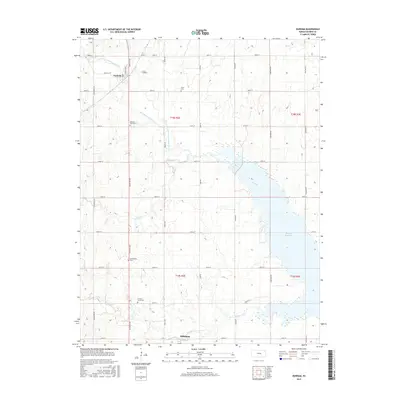
2015 Map of Durham
USGS Topo · Published 2015About this map
Durham serves as a northern focal point for this section of Marion County, situated along the upper reaches of the N Cottonwood River. The landscape is defined by the intersection of rural township roads like Santa Fe Ave and 290th St, and the significant expansion of the Marion Reservoir to the southeast. This man-made feature dramatically alters the natural drainage of Silver Cr and French Creek, reflecting mid-to-late 20th-century water management efforts in the region. Local heritage is preserved in several small burial grounds, including the Johannestal Cem, Frick Cem, and French Creek Cem, which mark the early footprints of German-American and Mennonite settlement. At the southern edge, the outskirts of Hillsboro begin to emerge, connected to the northern communities by a rigid grid of agricultural thoroughfares.
Find a feature on this map
35 named features on this map. Tap any name to fly to it.
Don’t see what you’re looking for? This feature index may not catch every label — zoom into the map to look around manually.
Map Details
Editions of this 2015 Durham Map
This is the sole edition of this map. No revisions or reprints were ever made.
Other maps of this area

1889 · Newton
USGS Topo · 1:125,000

1889 · Abilene
USGS Topo · 1:125,000

1894 · Newton
USGS Topo · 1:125,000

1894 · Abilene
USGS Topo · 1:125,000

1955 · Hutchinson
USGS Topo · 1:250,000

1959 · Hutchinson
USGS Topo · 1:250,000

1964 · Ramona
USGS Topo · 1:24,000
1964 · Gypsum SE
USGS Topo · 1:24,000
1964 · Tampa
USGS Topo · 1:24,000

1971 · Durham
USGS Topo · 1:24,000