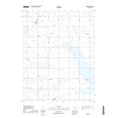
2018 Map of Durham
USGS Topo · Published 2018About this map
Durham and the northern reaches of Hillsboro sit at the center of this agricultural landscape in Marion County, where the N Cottonwood River and North Cottonwood River carve through the plains. The region is defined by a dense grid of section roads, including Santa Fe Ave and Goldenrod Rd, which facilitate transport between the small settlements and the surrounding farms. Local genealogy and community history are anchored by several notable burial sites scattered across the township lines, such as Frick Cem, Durham Park Cem, Johannestal Cem, and French Creek Cem. These small cemeteries, often located near watercourses like Silver Cr or French Creek, represent the early family settlements and religious congregations that established this part of the Kansas prairie. The map captures the traditional land divisions of T18S and T19S, illustrating the enduring layout of rural life and land ownership in the early 21st century.
Find a feature on this map
34 named features on this map. Tap any name to fly to it.
Don’t see what you’re looking for? This feature index may not catch every label — zoom into the map to look around manually.
Map Details
Editions of this 2018 Durham Map
This is the sole edition of this map. No revisions or reprints were ever made.
Other maps of this area

1889 · Newton
USGS Topo · 1:125,000

1889 · Abilene
USGS Topo · 1:125,000

1894 · Newton
USGS Topo · 1:125,000

1894 · Abilene
USGS Topo · 1:125,000

1955 · Hutchinson
USGS Topo · 1:250,000

1959 · Hutchinson
USGS Topo · 1:250,000

1964 · Ramona
USGS Topo · 1:24,000
1964 · Gypsum SE
USGS Topo · 1:24,000
1964 · Tampa
USGS Topo · 1:24,000

1971 · Durham
USGS Topo · 1:24,000