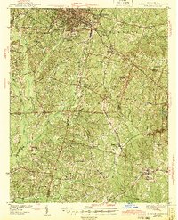
1943 Map of Durham South
USGS Topo · Published 1943About this map
Duke University anchors the northwestern corner of this landscape, situated just south of the growing city of Durham. During the early 1940s, the region was characterized by a transition from the urban tobacco and education hub of Durham to the agricultural townships of Cedar Fork and White Oak. The drainage patterns of New Hope River and Northeast Creek define the low-lying areas, while the Southern and Seaboard railroads provided essential transportation links for small communities like Morrisville and Cary.
Find a feature on this map
83 named features on this map. Tap any name to fly to it.
Don’t see what you’re looking for? This feature index may not catch every label — zoom into the map to look around manually.
Map Details
Editions of this 1943 Durham South Map
2 editions found
Other maps of this area

1943 · Durham South
USGS Topo · 1:62,500

1943 · Raleigh
USGS Topo · 1:62,500

1943 · Creedmoor
USGS Topo · 1:62,500

1944 · Creedmoor
USGS Topo · 1:62,500

1946 · Chapel Hill
USGS Topo · 1:24,000

1947 · Chapel Hill
USGS Topo · 1:31,680

1951 · Raleigh
USGS Topo · 1:62,500

1951 · Farrington
USGS Topo · 1:24,000

1951 · Durham South
USGS Topo · 1:62,500

1951 · Durham North
USGS Topo · 1:62,500