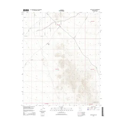
2014 Map of Dutch Flat SE
USGS Topo · Published 2014About this map
McCracken Mountains rise at the southern edge of this Mohave County landscape, where the high desert terrain meets a network of seasonal watercourses. The northern portion of the sheet is dominated by the Mojave Desert and the broad expanse of Dutch Flat. A distinctive grid of named roads, many with evocative frontier-style names like Six Shooter Rd, Lost Loot Rd, and Bonanza Rd, suggests a pattern of modern land parcels and recreational access within the arid environment.
Find a feature on this map
27 named features on this map. Tap any name to fly to it.
Don’t see what you’re looking for? This feature index may not catch every label — zoom into the map to look around manually.
Map Details
Editions of this 2014 Dutch Flat SE Map
This is the sole edition of this map. No revisions or reprints were ever made.
Other maps of this area

1923 · Signal
USGS Topo · 1:250,000

1942 · Signal
USGS Topo · 1:250,000

1950 · Prescott
USGS Topo · 1:250,000

1954 · Prescott
USGS Topo · 1:250,000

1958 · Prescott
USGS Topo · 1:250,000

1959 · Prescott
USGS Topo · 1:250,000

1960 · Prescott
USGS Topo · 1:250,000

1965 · Prescott
USGS Topo · 1:250,000
1966 · Castaneda Hills
USGS Topo · 1:62,500

1966 · Artillery Peak
USGS Topo · 1:62,500