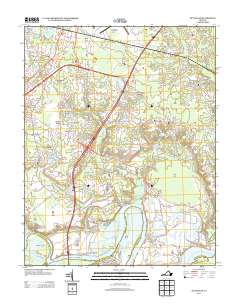
2013 Map of Dutch Gap
USGS Topo · Published 2013About this map
Varina and its surrounding communities sit at a historic bend of the James River, where the landscape is defined by the deep indentations of the Jones Neck and Hatcher Island. This 2013 survey illustrates the complex intersection of colonial-era heritage and modern infrastructure, featuring the sprawling grounds of the Richmond International Airport and the strategic Fort Lee in the northern reaches. The area's significant past is etched into the terrain at Malvern Hill Battlefield and through riverfront landmarks like Curles Neck Mansion Wharf and Deep Bottom Landing. Modern residential developments such as Varina Meadows and Williamson Farms are woven between historic swamp lands and creek beds. The map details the drainage patterns of White Oak Swamp Cr and Fourmile Creek, providing a comprehensive look at how the region's wetland geography has influenced settlement patterns and land use from the James River up toward Turner Woods.
Find a feature on this map
113 named features on this map. Tap any name to fly to it.
Don’t see what you’re looking for? This feature index may not catch every label — zoom into the map to look around manually.
Map Details
Editions of this 2013 Dutch Gap Map
This is the sole edition of this map. No revisions or reprints were ever made.
Other maps of this area

1894 · Bermuda Hundred
USGS Topo · 1:62,500

1894 · Richmond
USGS Topo · 1:62,500

1895 · Richmond
USGS Topo · 1:62,500

1918 · Charles City
USGS Topo · 1:62,500

1920 · King William
USGS Topo · 1:62,500

1934 · Seven Pines
USGS Topo · 1:24,000

1934 · Richmond
USGS Topo · 1:24,000

1938 · Dutch Gap
USGS Topo · 1:24,000

1938 · Seven Pines
USGS Topo · 1:31,680

1938 · Drewrys Bluff
USGS Topo · 1:24,000