
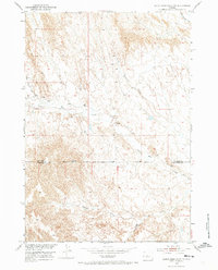
1951 Map of Dutch Nick Flat NW
USGS Topo · Published 1953About this map
Mueller Cabin stands as a lonely landmark within the drainage basin of Fifteenmile Creek in this 1951 survey of the Wyoming desert. The landscape is defined by an intricate network of intermittent waterways, including Rock Waterhole Creek, Bobcat Creek, and the winding Bobcat Draw, which carve through the high plains. This map was produced as part of the Department of the Interior program for the development of the Missouri River Basin, documenting the topography just as aerial photography methods like multiplex mapping were becoming standard.
Find a feature on this map
9 named features on this map. Tap any name to fly to it.
Don’t see what you’re looking for? This feature index may not catch every label — zoom into the map to look around manually.
Map Details
Editions of this 1951 Dutch Nick Flat NW Map
2 editions found
Other maps of this area

1951 · Sucker Dam
USGS Topo · 1:24,000

1951 · Dutch Nick Flat
USGS Topo · 1:24,000

1951 · Dutch Nick Flat SW
USGS Topo · 1:24,000

1951 · Gillies Draw
USGS Topo · 1:24,000

1951 · Sheep Mountain
USGS Topo · 1:24,000

1951 · Tatman Mountain
USGS Topo · 1:24,000

1951 · Wardel Reservoir
USGS Topo · 1:24,000

1951 · Dead Indian Hill
USGS Topo · 1:24,000

1955 · Cody
USGS Topo · 1:250,000

1958 · Cody
USGS Topo · 1:250,000