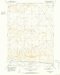
1951 Map of Dutch Nick Flat
USGS Topo · Published 1952About this map
Dutch Nick Flat and the surrounding rangelands of the Missouri River Basin are defined here by a sophisticated network of irrigation and water management at the start of the 1950s. The southern portion of the map is dominated by the course of Gooseberry Creek, where a series of engineered waterways including the Holder Ditch, Holly and Niccolls Ditch, and Holland Ditch redirect flow across the arid terrain. This infrastructure supported local rural life, anchored by the Shryack School and a visible Pipe Line running parallel to the creek. The drainage patterns of Fifteenmile Creek and its branches, the Middle Fork and South Fork, carve through the central topography, illustrating the vital importance of water rights and access in this part of Wyoming.
Find a feature on this map
14 named features on this map. Tap any name to fly to it.
Don’t see what you’re looking for? This feature index may not catch every label — zoom into the map to look around manually.
Map Details
Editions of this 1951 Dutch Nick Flat Map
2 editions found
Other maps of this area

1914 · Blue Mesa
USGS Topo · 1:62,500

1916 · Blue Mesa
USGS Topo · 1:62,500

1945 · Kirby
USGS Topo · 1:62,500

1946 · Kirby
USGS Topo · 1:62,500

1951 · Sucker Dam
USGS Topo · 1:24,000

1951 · Dutch Nick Flat
USGS Topo · 1:24,000

1951 · Schuster Flats
USGS Topo · 1:24,000

1951 · Schuster Flats NW
USGS Topo · 1:24,000

1951 · Dutch Nick Flat SW
USGS Topo · 1:24,000

1951 · Dutch Nick Flat NW
USGS Topo · 1:24,000