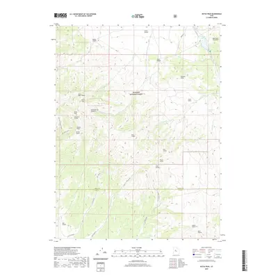
2020 Map of Dutch Peak
USGS Topo · Published 2020About this map
The high peaks and deep drainage systems of the Sheeprock Mountains and West Tintic Mountains dominate this 2020 landscape along the border of Tooele and Juab counties. Rising toward Dutch Peak and Black Peak, the terrain is marked by a complex network of canyons such as Harker Canyon and the aptly named Hard to Beat Canyon. Much of the area is managed as part of the Wasatch National Forest, where high-altitude water sources like Vernon Reservoir, Indian Springs, and Chokecherry Spring provide essential moisture in an otherwise arid environment. The map details the transition from sharp ridges like Greens Ridge to the more open Little Valley, connected by remote corridors including Pole Cyn Rd and Elkers Cutoff. This survey captures the topographical isolation of the Great Basin ranges just before the modern decade.
Find a feature on this map
37 named features on this map. Tap any name to fly to it.
Don’t see what you’re looking for? This feature index may not catch every label — zoom into the map to look around manually.
Map Details
Editions of this 2020 Dutch Peak Map
This is the sole edition of this map. No revisions or reprints were ever made.
Other maps of this area

1885 · Sevier Desert
USGS Topo · 1:250,000

1885 · Tooele Valley
USGS Topo · 1:250,000

1953 · Tooele
USGS Topo · 1:250,000

1953 · Delta
USGS Topo · 1:250,000

1955 · Tooele
USGS Topo · 1:250,000

1958 · Delta
USGS Topo · 1:250,000

1962 · Delta
USGS Topo · 1:250,000

1963 · Maple Peak
USGS Topo · 1:24,000
1963 · Sabie Mountain
USGS Topo · 1:24,000

1963 · Dutch Peak
USGS Topo · 1:24,000