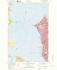
1968 Map of Duwamish Head
USGS Topo · Published 1969About this map
The waters of Puget Sound define this coastal survey, which highlights the heavy urban expansion of Seattle and its island neighbors in the late 1960s. The shoreline is a hub of maritime activity, marked by numerous transit routes including the Seattle-Winslow Ferry and the Fauntleroy-Vashon-Southworth Ferry. On the mainland, the residential growth of West Seattle is evident through dense street grids and established community anchors like West Seattle High Sch and James Madison Jr High Sch. Across the water, Bainbridge Island and Vashon Island show smaller nodes of development like Creosote and Vashon Heights. Noteworthy local landmarks such as the Laurel Beach Sanatorium and Schmitz Park provide a detailed look at the social and institutional geography of the sound just before the decade's close.
Find a feature on this map
43 named features on this map. Tap any name to fly to it.
Don’t see what you’re looking for? This feature index may not catch every label — zoom into the map to look around manually.
Map Details
Editions of this 1968 Duwamish Head Map
This is the sole edition of this map. No revisions or reprints were ever made.
Other maps of this area

1894 · Seattle
USGS Topo · 1:62,500

1895 · Snohomish
USGS Topo · 1:125,000

1897 · Tacoma
USGS Topo · 1:125,000

1897 · Seattle
USGS Topo · 1:125,000

1900 · Tacoma
USGS Topo · 1:125,000

1908 · Seattle
USGS Topo · 1:62,500

1909 · Seattle Special
USGS Topo · 1:62,500

1937 · Port Orchard
USGS Topo · 1:62,500

1942 · Gig Harbor
USGS Topo · 1:62,500

1943 · Gig Harbor
USGS Topo · 1:62,500