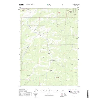
2018 Map of Duzel Rock
USGS Topo · Published 2018About this map
Klamath National Forest dominates this landscape in Siskiyou County, where steep drainage patterns and high ridges define the territory south of the Oregon border. The map reveals a complex network of canyons and gulches that feed into Moffett Cr and Cottonwood Cr, illustrating how the terrain dictated the placement of early forest service and ranching roads. Notable landmarks like the prominent Duzel Rock and the long spine of Scarface Ridge provide clear navigation points within the dense forest. The nomenclature found in the gulches, such as Moonshine Gulch, Whiskey Gulch, and Beef Corral Gulch, offers a linguistic link to the area's practical and perhaps more clandestine human history. This 2018 survey detail provides modern clarity on a rugged portion of the California backcountry, including the high peaks of Antelope Mtn and Piney Mtn.
Find a feature on this map
48 named features on this map. Tap any name to fly to it.
Don’t see what you’re looking for? This feature index may not catch every label — zoom into the map to look around manually.
Map Details
Editions of this 2018 Duzel Rock Map
This is the sole edition of this map. No revisions or reprints were ever made.
Other maps of this area

1886 · Shasta
USGS Topo · 1:250,000

1894 · Shasta
USGS Topo · 1:250,000

1922 · Shasta Valley Sheet No 3 S
USGS Topo · 1:24,000

1923 · Sawyers Bar
USGS Topo · 1:125,000

1931 · Etna
USGS Topo · 1:96,000

1932 · Yreka
USGS Topo · 1:96,000

1934 · Etna
USGS Topo · 1:125,000

1939 · Yreka
USGS Topo · 1:125,000

1948 · Weed
USGS Topo · 1:250,000

1950 · Weed
USGS Topo · 1:250,000